Nozawa Onsen Accommodation, Nagano, The Alps Japan
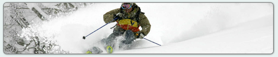
Nestled in the Japan Alps is a magical place steeped in culture and with some terrific skiing and boarding. Nagano was home to the Winter Olympics in 1998.
Get in touch if keen to get knee deep in powder or neck deep in a Hot Spring soon…
Video
Check out our video of our 4 main properties below.
Nozawa Onsen is a very traditional town with beautiful hot springs, friendly locals, and awesome snow. Our Lodge gives you amazing value and we have a range of accommodation to suit any budget.
The Lodge is only 100m to the slopes and short stroll to town
Relaxed and comfortable atmosphere
In the centre of Japan’s main Island Honshu easy access from anywhere
You can fly direct to Tokyo and there is a shuttle bus direct to the Lodge
English and Japanese Speaking Staff to help with all your needs
Unique and beautiful place with breathtaking nature and culture
Nozawa Village is also famous for its hot springs, there are many nearby
Lots of terrain, with Gondolas, high speed quads, and long runs – very few lift lines
Thanks Mark – we were first invited to Nozawa years ago and have been enjoyed the skiing, the village and your hospitality ever since. Thanks for helping us enjoy it so much,
We have a fine and mostly sunny morning in Nozawa Onsen. There is some low lying fog in the valley which will make a nice view from the top early. Temperatures are still quite warm with an inversion layer but the snow has held up very well during this recent warm spell with minimal loss of coverage.
Early on the lower groomers will be firm and fast before softening later today. Positive temperatures in the top half of the mountain mean the snow will slushy from the outset. Off piste will be lacklustre at best until we get some fresh snow, expected overnight.
Finally, this warm period will come to an end with a strong and prolonged series of fronts moving in from the NW. Tomorrow will be excellent, but Wednesday will be even better with very cold temperatures and a decent top up of snow. Around 30cm is expected before this time, probably more. Snowfalls will continue until Friday, which will be clear. On Saturday additional snowfalls are forecast. This is subject of revisions over the coming week.
Its partly cloudy here in Nozawa Onsen this morning. We have some mid to high level altostratus cloud affected by strong wind sheer. This tends to indicate it will be windy at the peak today, so some lifts may be placed on wind hold. The visibility below the cloud layer is excellent, look for patterns of sun streaking across the surrounding ranges.
Unfortunately we have some warm temperatures today, positive across all elevations of the mountain. As a result soft and forgiving spring like conditions will prevail. Head for high traffic groomers which will retain the greatest speeds. Also worth a look is the ski jump competition which is taking place near the bottom of skyline and the downhill event on Kandahar.
Luckily these warm temperatures will soon move on. The freezing level is forecast to take a massive nosedive around lunch tomorrow. Moderate snowfalls are expected commencing Monday night, continuing until Thursday. Temperatures will be very cold, around -12C at the summit, before windchill. Following this extended snowy period we should see clear conditions before further forecast snowfalls next weekend. Very cold temperatures will remain throughout.
A slightly overcast morning here in Nozawa Onsen today. We have some high clouds and it looks like it will be a mostly sunny morning and afternoon. Its forecast to get slightly warm later and so the best skiing areas will be up as high as possible, the Yamabiko area for example. The park at pipe will also be worth a visit in the softening conditions.
Yesterday stayed windy and cloudy with occasional snow showers for the duration. Again the best skiing areas were up high as the lower slopes were scoured and rain affected from the night before. Yamabiko offered some nice fresh snow early on and the blustery conditions kept most punters away. This meant there were fresh tracks even in obvious locations for most of the morning.
According to the forecast tomorrow should be quite warm with the possibility of a few showers before a dramatic and extended cold front will move through returning the region to classic winter temperatures and powder. Snowfalls should start on Monday when the freezing level gradually lowers and we expect moderate snowfalls to continue until Wednesday night, possibly longer.
Its an overcast morning in the village this morning. As expected temperatures are mild but at least there is no sign of the expected rain for the time being. There is a strong inversion layer across the mountain with warmer temperatures at the top then the bottom. The best skiing and boarding today will be had on the groomed runs and the park will be good fun as well. Off piste runs will be heavy going with the predicted warm temperatures.
Yesterday was good fun, again better than expected. Bluebird conditions with good visibility. North facing off piste runs held nice consolidated powder, good to manage at high speeds. South facing slopes were good early but became sun affected during the afternoon The groomed runs were also fantastic with the cool temperatures and light crowds.
We a still expecting wild swings in the freezing level over the coming days. Temperatures will drop dramatically overnight and around 10-20cm of powder is expected. Saturday should be warming but nice early on. Sunday will be warm with potential of rain. Moving on, we should be seeing some more decent falls of snow from Monday onwards with a return to the traditional NW airstream that brings Japan plenty of pow.
It looks like today will clear faster than expected. We currently have some puffy cumulus clouds rolling over the hills spaced with crystal clear blue skies. Temperatures are cold and will combine well with the fresh snow that we received overnight. Total falls since last lifts yesterday include 3cm at Yamabiko, 5cm mid mountain and a dusting in the village. It was windy up top overnight so there will be sure to be stashes much deeper than the indicated amounts. Head for sheltered gullies and trees for maximum powder enjoyment.
Yesterday was a day with some interesting weather conditions. The morning started off fine and sunny with nice snow conditions. However as the day progressed snow on the south facing slopes turned into wet crud. North facing off piste slopes retained moderately heavy powder in the shade. Overall the best runs were had at the Yamabiko trees and then the groomed runs, which were smooth and fast.
Later in the afternoon some ominous storm clouds moved in from the south west and the winds intensified. It was interesting skiing in such conditions, like being at the beach in summer when a storm hits. Later in the evening we experienced a very brief period of rain before it quickly turned to snow. Good to say there was much less rain then expected.
Its a real mixed bag when the forecast of the week ahead is examined. The freezing level is expected to go up and down like a yoyo. Cold temperatures are set to remain until later this afternoon, when temperatures will increase overnight quite dramatically. Tomorrow looks to be warm and overcast with prefrontal moisture moving up from the south. An intense but short lived front is due Thursday night/Friday morning. Following that there is another warm day expected Sunday before further snowfalls on Sunday.