Nozawa Onsen Accommodation, Nagano, The Alps Japan
Nestled in the Japan Alps is a magical place steeped in culture and with some terrific skiing and boarding. Nagano was home to the Winter Olympics in 1998.
Get in touch if keen to get knee deep in powder or neck deep in a Hot Spring soon…
Video
Check out our video of our 4 main properties below.
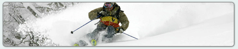
Nozawa Onsen is a very traditional town with beautiful hot springs, friendly locals, and awesome snow. Our Lodge gives you amazing value and we have a range of accommodation to suit any budget.
The Lodge is only 100m to the slopes and short stroll to town
Relaxed and comfortable atmosphere
In the centre of Japan’s main Island Honshu easy access from anywhere
You can fly direct to Tokyo and there is a shuttle bus direct to the Lodge
English and Japanese Speaking Staff to help with all your needs
Unique and beautiful place with breathtaking nature and culture
Nozawa Village is also famous for its hot springs, there are many nearby
Lots of terrain, with Gondolas, high speed quads, and long runs – very few lift lines
Thanks Mark – we were first invited to Nozawa years ago and have been enjoyed the skiing, the village and your hospitality ever since. Thanks for helping us enjoy it so much,
At the moment in the village we have some light snow falling, which has continued on and off for the past 12 hours. Temperatures are cold so the snow quality will be very good. Since last lifts yesterday we have had around 10cm of accumulation at the the summit and 20cm across the mid mountain. This indicates windblown conditions, but at the moment the wind is light.
Yesterday was an epic day on the hill. Very few people meant it was possible to have entire runs to yourself. Amongst the trees there were vast fields of untracked powder which was perfect depth with around 30cm of accumulation throughout the day.
Looking at the forecast ahead we should see a clearing trend later in the afternoon and a full bluebird day tomorrow. Unfortunately temperatures should warm briefly tomorrow before further snowfalls set in Sunday. At this point in time moderate to heavy falls are expected.
Current weather conditions, dumping! After disappointing snowfalls, or lack thereof yesterday we finally have the sustained moderate falls that the forecast models were predicting. Since close of lifts yesterday 10cm has accumulated at Yamabiko and 20cm has collected across the mid mountain. This indicates windy conditions up top so the best riding will be had on the lower three quarters of the mountain. Head to the trees or lower groomers for improved depth perception in the near whiteout conditions.
Yesterday saw mostly overcast conditions and passing heavily isolated snow showers early before the clouds ascended to higher elevations later in the afternoon. The riding was good with cold temperatures and plenty of nice deep fresh amongst the trees. Crowds were non-existent, it was possible to have an entire run to yourself.
According to the forecast we should see a gradual decline in snowfalls today and tomorrow snow showers will become isolated, clearing later in the day. Friday is set to be sunny bluebird all day but will warm considerable to a freezing level of around 1200m with a tropical airstream. Next significant snowfalls are expected Saturday night into Sunday.
Judita hiking out through too deep snow on Sunday.
Base up top: 280 cm Temp Top; -7 Degrees
Base at bottom; 160 cm
New Snow since close: 10 cm
Weather; Snow showers
We have some extremely variable weather in Nozawa Onsen. Highly isolated but frequent snow showers are producing dumps which last less than half an hour interspersed with blue skies and sun. For today we expect some moderate falls, heavy at times and cooling temperatures. Winds will be moderate on the higher reaches of the mountain.
The best skiing areas today will be all over the mountain for intermediate to advanced skiers and boarders. There will be some nice stashes of powder about the trees with 10cm having fallen at Yamabiko since last lifts yesterday. Beginners and kids might be more at home on the groomed runs of the lower half with lighter winds and improved visibility.
Yesterday saw very good conditions across all elevations. The morning was epic with very cold temperatures, which kept the snow fast and dry, and bluebird skies. The powder had consolidated since the heavy falls of the day before which opened up a lot of terrain. Yamabiko was once again skiable as were all the other popular trees runs. North facing backcountry slopes had improved stability but south facing slopes were sketchy.
According to the forecast moderate falls should continue today before easing overnight, at which point light snow showers are expected. A clearing trend is expected from thursday afternoon. Friday should be clear but warm by the afternoon.
With only some clouds hovering over the mountains now it is clear that it is going to be a spectacular day! The snow stopped falling early last night after what was an intense 24 hours. During that time a grand total of 88cm was recorded as having fallen at Yamabiko and well over half a meter in the village. Off piste and the steeper blacks will be where its at today. Heading to steeper areas is a necessity to avoid getting stuck it the deep pow. For beginners the groomed runs will be nice and soft, perfect for comfortable trips to the ground.
Yesterday was by far the deepest days we had so far this season and possibly deeper than any day last season. Yamabiko was a no go, it was simply not steep enough for the chest deep snow. The blacks off skyline were awesome once they opened as were runs in the challenge area. Snow showers eased into the afternoon providing more manageable conditions on the high mountain and the crowds were very light for a Sunday. There were also reports of solid avalanches in the backcountry, more than big enough to kill, so be very careful today.
Looking at the forecast ahead we should expect snow showers to return this afternoon, increasing in intensity overnight. The forecast totals on an hour by hour basis for the next three days is less than the past system, but the extended duration should see accumulation of over half a meter in the next three days. Moderate to heavy snow are forecast for tomorrow, before easing to light to moderate on Wednesday. Clear skies should return by late Thursday.
There was a lot of expectation coming off the forecast yesterday and those who had high hopes will not be disappointed. At the moment we are experiencing the heaviest snowfall rates we have seen so far this season. It is dumping so hard that the visibility is not limited by clouds, but by the falling snowflakes themselves. Since the close of lifts yesterday we have had half a meter fall up top, 35cm mid mountain and 30cm in the village.
Head for the steeper areas if you want to go off piste today. Yamabiko trees may be hit and miss, might not be steep enough considering the snow depth. The blacks off skyline and the challenge area will all be excellent areas to get your powder fix today. For those just starting out or groomed runs stay on the lower half of the mountain to avoid the bitterly cold temperatures (its windy near the top) and limited visibility. The backcountry will be very dangerous and unstable today, be careful.
Yesterday was quite nice, warmer than expected but still good. Partly cloudy conditions continued for the day with the clouds only rolling through early evening. Best picks were the groomers as the remaining areas of powder quickly became tracked out by the weekend crowds.
According to the forecast, snowfalls are set to continue for the rest of the day, gradually subsiding to light falls by the late afternoon. Temperatures will remain very cold throughout. Tomorrow should clear briefly in the morning before snowfalls once again set in overnight monday into Tuesday. We expect moderate totals accumulating out of this system, around 30-40cm. Light snowfalls will continue into Wednesday coinciding with a very cold arctic airstream. The clouds should once again clear late Thursday and a fine day is expected on Friday.