Nozawa Onsen Accommodation, Nagano, The Alps Japan
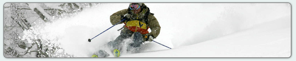
Nestled in the Japan Alps is a magical place steeped in culture and with some terrific skiing and boarding. Nagano was home to the Winter Olympics in 1998.
Get in touch if keen to get knee deep in powder or neck deep in a Hot Spring soon…
Video
Check out our video of our 4 main properties below.
Nozawa Onsen is a very traditional town with beautiful hot springs, friendly locals, and awesome snow. Our Lodge gives you amazing value and we have a range of accommodation to suit any budget.
The Lodge is only 100m to the slopes and short stroll to town
Relaxed and comfortable atmosphere
In the centre of Japan’s main Island Honshu easy access from anywhere
You can fly direct to Tokyo and there is a shuttle bus direct to the Lodge
English and Japanese Speaking Staff to help with all your needs
Unique and beautiful place with breathtaking nature and culture
Nozawa Village is also famous for its hot springs, there are many nearby
Lots of terrain, with Gondolas, high speed quads, and long runs – very few lift lines
Thanks Mark – we were first invited to Nozawa years ago and have been enjoyed the skiing, the village and your hospitality ever since. Thanks for helping us enjoy it so much,
Tully scoops into a narrow chute near Nozawa Onsen on Wednesday.
Base at top: 360 cm
Temp at Top: -9 Degree
Base at Uenotaira station: 280 cm
New snow since close: 20-30 cm
Weather: Light Snow
Heavy snow just keeps on falling here in Nozawa Onsen. After a pause in the falls yesterday evening, where we saw clear blue skies and a quality sunset, snowfalls have ramped up again overnight. Today we expect conditions to be much the same as yesterday, albeit with greater chance of good visibility later. Areas exposed to strong NW winds overnight will be wind scoured with a slight layer of irregular powder. The opposite faces will have deeper snow with very high avalanche danger off piste. Not worth the risk until the snow consolidates. The Challenge and Yamabiko area will likely offer the nicest turns for powder skiing and boarding.
Yesterday we saw strong snowfalls continue for much of the day adding 30cm to the growing base depth. Luckily the winds were not as strong as the night before, keeping lifts operating and powder hounds frothing. Despite recording 30cm of fresh the snow felt much deeper in deposition aspects, blown about by the powerful winds. In areas that were wind scoured, namely the NW aspects, the irregular icy base underneath was more than noticeable. All in all, another good day of skiing to add to the tally for 2017.
According to the forecast model runs we are due for some clear weather and good visibility. This will occur tomorrow morning in combination will cool temperatures. Sunday will be much warmer and the worst day for skiing in the next week ahead. But by Monday a prolonged cold NW flow will reestablish itself over the region resulting in heavy falls of snow. The greatest precipitation rates look to occur around Monday night and snowfalls will gradually ease into Wednesday.
Well this almost came out of nowhere! We were expecting a decent fall last night, but nothing too special until the forecasts made a sudden upgrade yesterday. Even in this hyper predicted day and age we still sometimes get surprises, such is the case now. Howling overnight winds kept many awake bringing heavy snow and blizzard conditions across the mountain. Since last lifts official measurements show (or thanks to the strong winds in this case an estimate) 30cm of fresh snow at Yamabiko, 30cm at Uenotaira and 15cm down here in town. Today strong winds, heavy snow and blizzard conditions are set to continue making for frigid but epic conditions riding. Extra layers are recommended and wind holds are to be expected. Today the power of nature can be appreciated amongst deep Japanese powder snow.
Yesterday we saw bluebird conditions last for most of the day. It was only late in the afternoon that we saw evidence of this approaching system as lenticular clouds built above the alpine peaks, tails of spindrift indication of storm force winds intercepting the higher elevations. The riding was good but not great, an icy base still well and truely affecting turns off piste. On piste was a smoother affair with quality turns especially earlier in the day. Temperatures remained slightly colder than expected keeping the snow quality high.
Snowfalls and blizzard conditions look to continue into the afternoon before easing overnight. Lighter snow showers are predicted for tomorrow before the weather breaks at some point in the afternoon. Saturday will be clear with light winds, but will warm during the afternoon. Sunday will warm as well thanks to a southerly inflow before another low pressure system take aim on the region, directing a NW flow towards Honshu from Monday onwards.
Today we wake with partly cloudy conditions and clear weather on the mountain. Unfortunately we haven’t had any fresh snow to top up the coverage overnight so conditions will be much the same as yesterday afternoon. Its likely the temperatures will warm during the afternoon and the snow will become slightly heavier later as a cold front approaches. As the daylight hours extend the lift operations have also changed time. From now until the start of April the Nagasaka gondola will run till 4pm, Hikage till 4:20pm and Yamabiko until 4pm. Extra hours on the hill are always welcomed.
Yesterday we had some excellent conditions mountain wide with knee deep fresh powder on top of an icy base and cold temperatures. For the first time in the season there were a few death cookies to watch out for but the groomers kept the on piste conditions nice and smooth. Another 10cm fell from first to last lifts topping up the cover and bringing the grand total to 50cm up top over the previous 24 hours. Visibility improved throughout the day finishing with a spectacular red sunset as the cloud base hovered just above Yamabiko.
Snowfalls will continue after tonight into tomorrow with moderate to heavy falls. The precipitation will gradually ease into Friday morning and I predict a nice sunset on Friday afternoon as the clouds break. Saturday looks to be clear as does Sunday morning. Early next week further snowfalls are on the cards. Looking like a decent seven day forecast overall.
Just like that the switch has flipped and we are back to full winter mode in Nozawa Onsen. The rain turned to snowflakes at around 330pm yesterday afternoon at village elevation quickly increasing towards heavy falls as the wind swung towards NW. Strong winds fanned the falls overnight and accumulations are heavily displaced towards the leeward slopes, resulting in 40cm at Yamabiko, 30cm at Uenotaira and 25cm down here in the village. I expect snowpack stability to be extremely low today thanks to rapid temperature drop and heavy windblown accumulations last night. Definitely a day to stay on piste where no shortage of fine powder will be found directly adjacent to the pistes. Temperatures are slightly colder than normal at -10c and the crowd levels are low. Expect few lift lines.
Yesterday was a poor day for comfort skiing and snowboarding with light rain falling for much of the day. However the snow was slushy, quite fast and didn’t become too sticky. So the quality was ok considering the precipitation. The rainfalls hardly made a dent in the deep winter snowpack providing a slight consolidation below the three meter mark up top. As the freezing level dropped during the afternoon the upper slopes froze and became hard and icy.
We should see light snow showers ease throughout today with perhaps even some breaks of clear weather later in the afternoon. Tomorrow will be a partly cloudy morning before high clouds roll over signifying an approaching cold front. More heavy snowfalls are expected tomorrow night and these will continue into Thursday and Friday. Temperatures will be generally cold, warming by half a degree or so by Friday. A clearing trend is forecast later in the week and the weekend looks like it’ll be generally fine. More snow is on the cards for early next week.
The atmosphere is latent with moisture this morning and not of the good kind. Light rain is falling and right to the summit of Mt Kenashi there are positive temperatures. So for those venturing outside today you would be wanting some of the finest Gortex around, or expect a good soaking. Thats the negative out of the way so lets take a look at the immediate positives. Snowfalls are on the way and very soon indeed. Tonight we will come under the influence of a brisk NW flow that will dump heavy snowfalls right on Nozawa. I said yesterday we may wake tomorrow with 30-40cm on the ground and I stand by this prediction this morning. But for now the skiing will be wet and slushy. Walking around town the snow feels very slippery so I am hopefully it won’t be sticky snow at all on the mountain today.
Yesterday we were set upon by warm sunshine and fantastic spring skiing opportunities. It was a fun filled day on the slopes with ski and snowboard demos on at Kandahar Raceway and a generally relaxed vibe on the pistes. The snow was decent, firm in the morning then becoming a kind of soft ice that was fast flowing in most trafficked areas. During the afternoon atmospheric views of the surrounding countryside abounded as bands of mid level clouds past over the region.
After tonight’s heavy snowfalls we should see light to moderate snow showers continue tomorrow with possible slight breaks of clear weather. Its likely stability will be very low thanks to a drastic temperature swing and rapid accumulation later tonight; tomorrow will be a day to keep cautious. Continued snowfalls are expected later in the week from a seperate NW flow that will commence on Wednesday night and last until at least Friday. Top ups will be continued and probably amounting to 20-30cm for each 24hour period associated. This weekend looks to be generally fine before another run of snowfalls from early next week.