Nozawa Onsen Accommodation, Nagano, The Alps Japan
Nestled in the Japan Alps is a magical place steeped in culture and with some terrific skiing and boarding. Nagano was home to the Winter Olympics in 1998.
Get in touch if keen to get knee deep in powder or neck deep in a Hot Spring soon…
Video
Check out our video of our 4 main properties below.
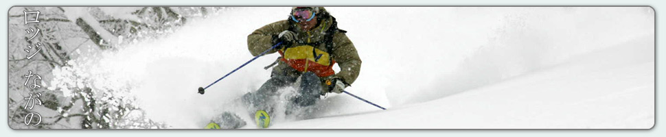
Nozawa Onsen is a very traditional town with beautiful hot springs, friendly locals, and awesome snow. Our Lodge gives you amazing value and we have a range of accommodation to suit any budget.
The Lodge is only 100m to the slopes and short stroll to town
Relaxed and comfortable atmosphere
In the centre of Japan’s main Island Honshu easy access from anywhere
You can fly direct to Tokyo and there is a shuttle bus direct to the Lodge
English and Japanese Speaking Staff to help with all your needs
Unique and beautiful place with breathtaking nature and culture
Nozawa Village is also famous for its hot springs, there are many nearby
Lots of terrain, with Gondolas, high speed quads, and long runs – very few lift lines
Thanks Mark – we were first invited to Nozawa years ago and have been enjoyed the skiing, the village and your hospitality ever since. Thanks for helping us enjoy it so much,
Wow, what a stunning sunny day it is outside today. Definitely not a day to be sitting inside here in Nozawa Onsen and what better way than to spend it outside, skiing in the beautiful Japanese Alps. Light winds, ample views and toasty sunshine will affect the mountainside today. It will be warm and spring-like with the freezing level quickly rising to around 1500m, meaning the snow will be fun and easy going mountain wide. Soft and slushy. One of my personal favourites for carving pleasure, Kandahar, is open for only the second time this season (word is they have been saving this piste for a special race event later in the year). As a result, every lift is running on the mountain today.
Yesterday was pretty similar throughout the afternoon yet much cooler in temperature. By around 1pm the clouds parted revealing a bright blue sky. As the day wore on the skiing improved as the icy pistes softened by means of sun exposure. Later in the evening a dazzling light show overhead as the setting sun cast a salmon glow over the town and mountain. A perfect way to end a good afternoon.
Tomorrow will be quite the opposite so make the most of the clear weather today. It will be a pretty miserable day with rain looking likely in the morning. Snow showers will lower to 1000m by the afternoon so it will be freezing at this point from mid mountain and above. Later in the night temperatures will cool even further and heavy snow is forecast right down to sea level. Its possible we will wake up on Tuesday with 30-40cm on the ground. These snowfalls will gradual ease into Tuesday becoming isolated during the evening. Further ahead, another good run of snowfalls is possible from Wednesday night onwards.
Violent spindrift being blown off Mt Hiuchi 2462m yesterday
Base at top: 310 cm
Temp at Top: -7 Degree
Base at Uenotaira station: 250 cm
New snow since close: 5-10 cm
Weather: Partly cloudy
It will probably be a very underrated day out there today. Although slightly busier due to the weekend crowds the snow will be of fine quality with 5-10cm recorded overnight and fairly cold temperatures. The lower mountain will likely be dust on crust material thanks to yesterdays rain. However the upper mountain would have been cold enough to snow for the duration and therefore offer some good skiing, especially later in the afternoon when the fog and clouds move away. The recommendations for today are Yamabiko for the advanced riders and Uenotaira or mid station lifts for the beginners to intermediates. Word is that there is also some ski and snowboard demo over at Kandahar; worth a look.
Strong winds yesterday gusting up to 100km/h forced the closure of the entire upper half of the mountain all day. This is very unusual. Thanks to the low elevation of ski resorts Japan is not a windy place during winter in comparison with other mountain areas. The lower half of the mountain was open for business as usual. With warming temperatures yesterday the snow was slushy, a little slow in parts.
We are expecting a warm day tomorrow with some high cloud. Not too dissimilar to yesterday however even a touch warmer. Rain is looking possible during the evening into Monday. Monday will be a poor days skiing. Looking further ahead we may receive some decent dumps of snow during the week with the biggest falls occurring on Monday and Wednesday night interspersed by isolated snow showers. Later in the week continued snowfalls are predicted from Thursday until Saturday.
Unexpectedly we have some strong winds this morning forcing closure of the entire upper half of the mountain. The Hikage gondola and Paradise lift are the two highest running lifts presently. Across the valley the powerful southerly winds are whipping impressive spindrift off the summit of Mt Hiuchi. It may feel benign down in the village but realities may change drastically with altitude. A good day to rest sore feet.
Yesterday was pretty much as good as it gets. The only downside that there wasn’t any fresh falls overnight preceding. The morning offered some of the most impressive long range views that can be had. Mountain ranges usually hidden by haze or cloud were crystal clear. It was even possible to spot boats plying the Sea of Japan off to the west. The snow was excellent, remaining dry and chalky into the afternoon at Yamabiko, but became sun affected on the south facing slopes. The treed areas are now very nicely filled in with only a few brushes poking through. If every day was like yesterday we would always be very tired!
We are expecting snowfalls tonight across the mountain and these are predicted to continue into tomorrow before gradually easing. Perhaps 10-15cm will accumulate on the upper mountain. Sunday will be generally fine before rain showers move over in the evening, turning to snow at some point on Monday. From then on a decent run of snow is forecast during next week with continued NW winds.
A good enough day for Brad to get out on the hill.
Base at top: 360 cm
Temp at Top: -8 Degree
Base at Uenotaira station: 285 cm
New snow since close: 0 cm
Weather: Clear
Even though we are in Japan apparently its Australia day today. Weird. Regardless the snow is epic and the sun is shining. It will be as good as it can ever be this today. I was going to camp atop the summit last night, however the incessant snowfalls and freezing temperatures forced me to reconsider at the eleventh hour. I now regret that decision. Its a stunning morning; almost entirely clear and blue with views stretching off over huge distances. The Japanese Alps, Sea of Japan and Myoko Stratovolcano are all right there centre stage, a backdrop for today. Perhaps the day of the season and everywhere will be good. Don’t forget the camera.
Yesterday was downright epic. Snowfalls continued for the duration with surprisingly only a brief patch of sunshine. This run of snowfalls has really stood above the forecast predictions with surprise after surprise. Untracked areas were found from first lifts to last with deep powder blanketing the resort and few people, although more than Tuesday. Superlatives cannot describe the quality and level of enjoyment for all the skied and boarded today.
As we take a look at the forecast we must lower our expectations from the lofty heights of the last two weeks. After todays sublime skiing we are in for some weird weather. Tomorrow will warm rapidly into the afternoon with some rain, or liquid powder as I like to call it during the afternoon. Luckily it will turn to snow overnight probably adding net gains to the coverage resort wide. Then again on Sunday more rain followed by more snow that will continue for much of next week at this stage. Temperatures will be a touch warmer with snow falling only to 400m above sea level.
Looks like we are in for another day that will be up there with the best. Light snow has continued to fall overnight refreshing the mountain back to a clean slate. Temperatures remain very cold and the winds are moderate with limited visibility becoming apparent with altitude gain. If the past few days are anything to go by crowds will be non existent. Time to get out there.
Yesterday was an insane day. Heavy snow feel all day long providing fresh tracks right up to last lifts with 25cm accumulating during the daylight hours. There was hardly anyone on the mountain, probably due to the extreme cold. Deep powder snow that blanketed the resort was as good as it gets; light and extremely dry it was particularly easy to manoeuvre through. With fresh tracks from first to last lifts who can complain. It sure is a hard life!
For today, snow showers will gradually ease becoming more isolated later. By early tomorrow we are expecting clear weather and it will probably be another day to remember with blue sky and so much cold, fresh powder. On Friday it will be good again earlier before temperatures rapidly warm. Unfortunately we may experience some rain in the afternoon which will quickly turn to overnight snow. Saturday is looking to be partly cloudy before another tropical low pressure reaches the mountains. We should see further showers from this on Sunday, turning to snow by Monday. All in all, extremely variable weather into the foreseeable future. Nothing too unusual for this stage in the season though. Im sure the snow tap will be turned on once more very soon.