Nozawa Onsen Accommodation, Nagano, The Alps Japan
Nestled in the Japan Alps is a magical place steeped in culture and with some terrific skiing and boarding. Nagano was home to the Winter Olympics in 1998.
Get in touch if keen to get knee deep in powder or neck deep in a Hot Spring soon…
Video
Check out our video of our 4 main properties below.
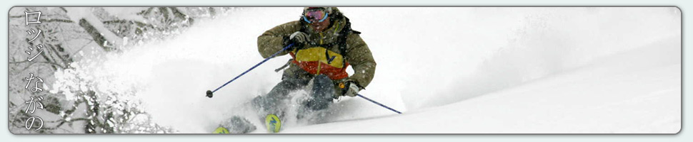
Nozawa Onsen is a very traditional town with beautiful hot springs, friendly locals, and awesome snow. Our Lodge gives you amazing value and we have a range of accommodation to suit any budget.
The Lodge is only 100m to the slopes and short stroll to town
Relaxed and comfortable atmosphere
In the centre of Japan’s main Island Honshu easy access from anywhere
You can fly direct to Tokyo and there is a shuttle bus direct to the Lodge
English and Japanese Speaking Staff to help with all your needs
Unique and beautiful place with breathtaking nature and culture
Nozawa Village is also famous for its hot springs, there are many nearby
Lots of terrain, with Gondolas, high speed quads, and long runs – very few lift lines
Thanks Mark – we were first invited to Nozawa years ago and have been enjoyed the skiing, the village and your hospitality ever since. Thanks for helping us enjoy it so much,
What a day it was yesterday! For those lucky enough to get up early would have seen some amazing atmospheric clarity as they rose above the valley fog aboard the Nagasaka gondola. The Sea of Japan and the horizon over the ocean was clearly visible. Even Sado Island way off to the NW was sighted. The mighty Japanese Alps all the way to Hakuba extended across the skyline providing ample mind skiing. It wasn’t until around midday when photochemical haze spoiled the long distance views. And what about the snow. It was phenomenal. Deep, cold powder snow that was much improved from the day before. Excellent skiing was had across the mountain with nothing but happy faces (except for those who missed out). Many of the multi season staff were remarking that it was one of the best days skiing they have ever had, myself included. More again please 🙂
We woke this morning at 630am to some light flurries of snow and the loud sirens of the earthquake alarm. Luckily nothing eventuated, however earthquakes are always in the back of your mind in Japan. From last lifts to 8am we had 5cm of fresh snow fall, perhaps a little more since then. If you are paying close attention to the base depth figure you may have noticed a decline back towards the three meter mark. This is simple the natural compaction of the snowpack as the snowflakes break down and air in compressed out after fresh snowfall has occurred.
Out skiing and boarding today you’ll notice the snow is slightly heavier powder, similar to Tuesday. Nevertheless it will be a fun day on the hill with good turns through the Yamabiko trees and smooth groomers across the lower pistes. The crowds are light and the mountain is currently shrouded by fog above 1000m.
According to the forecast we expect light snow showers to continue on and off today, perhaps clearing later this afternoon. Then tomorrow night we will see another round of snow of much the same quality as today. Which will continue into Sunday morning. From then one another much colder batch of snow is due for early next week. potentially clearing again around Wednesday or Thursday.
A villager exits the cooking onsen after recent heavy snowfalls
Base at top: 330 cm
Temp at Top: -8 Degree
Base at Uenotaira station: 245 cm
New snow since close: 20 cm
Weather: Clear
The storm is over. Delivering a parting gift of 20cm overnight there are now clear blue skies and bright sunshine above the mountains. A bluebird powder day. In the valleys we have a dense but spectacular sea of fog. Bring the camera up today as there will surely be some amazing views with fresh snow frosting the trees framed by a backdrop of piercing snow clad peaks. To recap from the past week we have received a grand total of 385cm from the entirety of this run of snow. It is remarkable to have such a prolonged run of heavy falls and we are now well set up for the long season ahead. The skiing today will be good, best early as temperatures are forecast to climb during the afternoon. When this happens the best snow will be found on north facing slopes and shaded valleys such as Nagasaka, Challenge and of course, Yamabiko. Some slopes may become sun affected and heavy especially on the lower mountain.
Yesterday we had some unusual weather patterns. While heavy snow continued to fall, adding another 20cm throughout the day, temperatures were surprisingly high, hovering at -5c up top and 0c in the village. This made the snow heavy going and vastly different from the perfection of Monday. Nevertheless it was still much more fun than working so who can complain. As expected the mountain was nicely uncrowded.
According to the forecast we should have a few days of variable weather and overnight snow showers. Light snow is expected overnight tonight before a partly cloudy afternoon for tomorrow. Friday will warm a touch before heavy snow moves over the region once more overnight into Saturday. Further moderate to heavy falls are expected into early next week.
It just never stops. For the 7th day in a row it has dumped overnight in Nozawa Onsen. This time 25cm has fallen on the upper slopes and 25cm in the village. This is amazing. A week ago I said to expect some huge figures upcoming and that has been the case. Since the 10th we have had a storm total of 345cm, which is nearly one third of the average annual snowfall in the space of a week. Two weeks ago we were looking down the barrel of a very marginal season indeed. How quickly that can change! Expect again outstanding riding conditions with piles of powder even on piste, silky smooth squeaky cold groomers and maybe even some views later this afternoon.
Overnight we received reports of a missing family on the mountain. By all accounts that would have faced a freezing night on the hill. The latest word of mouth is that they have been found alive. Apparently they dug a snow cave which would have almost certainly saved their life. If you somehow find yourself stuck in a similar situation the best course of action is to remain calm, try make contact via mobile phone, try not to become sweaty (it will make you colder/freeze later in the night) and build a snow cave for warmth and shelter. Do not go into the backcountry if you don’t know what your doing. Do not duck ropes.
I have never skied in Alaska, but yesterday provided the type of snow one might expect when skiing a mind bending spine wall on the slopes of an otherworldly Alaskan peak. Wind compacted powder. Perfect for charging at high speed with utmost confidence and control. The day of the season for sure. More snow than the relatively light crowds could track within the day, strong winds and continued snowfalls replenishing drifts with amazing frequency. Extremely cold temperatures ensured the snow remained in superb condition all day long. There just isn’t enough daylight hours.
Gazing towards the forecast the snow train continues. We have reached the tail end of the current run and snowfalls are expected to taper off later today, clearing tomorrow morning into a stunning bluebird. Partly cloudy conditions will persist into Thursday and even perhaps Friday. Right in time for next weekend we are then expecting another run of heavy snow. While not as extensive as last weeks storm/s it looks like we’ll get more than a few overnight deluges of the white stuff we all crave.
All the fire in Nozawa can’t stop this storm! The morning after the world renowned cultural event, the Nozawa Onsen Dosojin Fire Festival and there will no doubt be many sore heads about town. But those with an eye on the pow will reap rewards this morning with classic winter powder skiing conditions. Heavy snowfalls and blizzard conditions continued overnight refreshing the slopes to a clean slate. There will be no shortage of wind features and heaps of fun skiing and boarding on offer. Be careful, the snow is in parts deeper than head high. Don’t get yourself into anything you can’t get yourself out of.
Yesterday was another best day of the season. At least equal to the day before. The snow was much more wind compacted, making significantly easier skiing and boarding. Strong winds persisted all day with arctic windchill towards the summit. Snowfalls also continued adding another 17cm of fresh.
Last night the age old tradition of the Dosojin Fire Festival was enjoyed by hundreds under a blanket of snow. As always, it was a somewhat dangerous spectacle as the tower was attacked, defended and eventually burned to the ground. The fire burned with such ferocity that falling snow flakes melted into rain drops in the immediate vicinity. Even after many times of viewing the mesmerising display never gets boring and is well worth the trip alone to Nozawa Onsen.
According to the forecast we are in for another day much the same as the past two. Snowfalls will intensify overnight adding significant numbers to the fast growing base. The flakes will gradually ease into Tuesday, this will mark the end of this extremely cold and powerful storm system. By Wednesday we expect a beautiful clear bluebird and no additional snowfalls. Further ahead, another strong system is looking plausible around next weekend.
A vicious gale roars outside the window. Snow is blown across the fields and then back again filling in any freshly cleared track within the hour. Bushes that once stood meters above the snow are all but gone. Such is the 36 hour blizzard in Nozawa Onsen. The storm continues with only a brief sign of pause this morning, before unleashing once more.
Since last lifts yesterday snow has fallen to the amount of 40cm, but with strong winds its hard to trust this measure (could be less or more). Since the snow started falling days ago we have had 245cm (at Yamabiko) transform the mountain slopes into an unfamiliar wonderland. It will be good today. It will be deep, very deep. Don’t head off piste as there are some extremely unstable layers and the likelihood of becoming stuck is an almost certainty. There are clueless people out there dropping things they shouldn’t, without even know where it funnels too. Don’t be one of these people. Save some energy for the fire festival and have an amazing day.
Yesterday was the deepest day in recent memory. Its unusual to have such prolonged heavy snowfalls in even a good season, which up until now was not. Heavy snow filled in tracks lap after lap. Extreme cold kept the snow in amazing condition; light and dryer than the Sahara. Even when chopped up it was still amazing skiing. These are the days we live for.
As the forecast stands we are just over half way through this current storm cycle. The heaviest falls were expected yesterday and slightly lighter but still powerful falls are expected today and tonight. Monday have received an upgrade of snowfalls but it won’t be as cold as yesterday. On Tuesday snowfalls will become light and isolated before potentially clearing on Wednesday and Thursday. Another good dump of snow is looking possible for next weekend.
Update: Since the opening of lifts at 8am another 10cm has fallen taking the base over 3meters. For the record we cracked 2meters on Friday night.