Nozawa Onsen Accommodation, Nagano, The Alps Japan
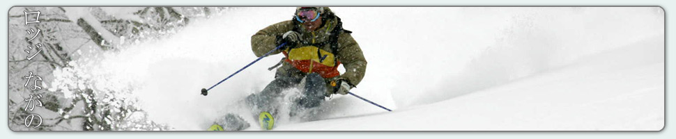
Nestled in the Japan Alps is a magical place steeped in culture and with some terrific skiing and boarding. Nagano was home to the Winter Olympics in 1998.
Get in touch if keen to get knee deep in powder or neck deep in a Hot Spring soon…
Video
Check out our video of our 4 main properties below.
Nozawa Onsen is a very traditional town with beautiful hot springs, friendly locals, and awesome snow. Our Lodge gives you amazing value and we have a range of accommodation to suit any budget.
The Lodge is only 100m to the slopes and short stroll to town
Relaxed and comfortable atmosphere
In the centre of Japan’s main Island Honshu easy access from anywhere
You can fly direct to Tokyo and there is a shuttle bus direct to the Lodge
English and Japanese Speaking Staff to help with all your needs
Unique and beautiful place with breathtaking nature and culture
Nozawa Village is also famous for its hot springs, there are many nearby
Lots of terrain, with Gondolas, high speed quads, and long runs – very few lift lines
Thanks Mark – we were first invited to Nozawa years ago and have been enjoyed the skiing, the village and your hospitality ever since. Thanks for helping us enjoy it so much,
Sake gifts to those hauling the gigantic tree down for the fire festival yesterday
Base at top: 235 cm
Temp at Top: -10 Degree
Base at Uenotaira station: 190 cm
New snow since close: 40-50 cm
Weather: Blizzard
Buried, inundated or swamped are all words to describe what we are currently experiencing in Nozawa Onsen. Right now the precipitation rates are truely amazing with very heavy snow and blizzard conditions right down to the village. Since last lifts yesterday we have had a windblown 40-50cm fall on the upper mountain and 45cm down in the village. But since these recordings were taken some time between 6 and 7am id say the depth is significantly more than this by now, perhaps 70cm+. Early this morning the snow came in thick and fast, even the under street heating was no match for the powerful falls. The storm total now stands at 175cm officially. Its growing fast!
There are only a few places on the mountain you can ski with such depth. They are as steep as possible to avoid becoming bogged down and stuck fast. Id recommended staying on piste or very near to the piste at least until the snow settles. Its going to be a dangerous day out there today. For those who are a bit overwhelmed by the stormy weather, head down to the village where today the gigantic structure that will be set alight in tomorrows fire festival is being constructed.
Yesterday we had a magic day on the mountain. Light to moderate snowfalls continued for much of the day with a few breaks of lighter air in between. The snow was top quality, powder laps right down to the village. Overnight falls of 30cm are the perfect depth for Nozawa Onsen. These layers are the perfect amount to ski all areas of the resort without becoming too bogged down in shallow terrain. In other words, you need not straight-line Yamabiko. At 1pm the large centre tree was dragged down from the mountain to be used in the Fire Festival tower with many Sake refreshments flowing!
Looking at the forecast ahead we are about a third of the way through this impressive storm front. Very heavy snow is expected to continue for the rest of today and tonight. Precipitation rates will ease a touch tomorrow and then again on Monday. On Tuesday snow showers will become lighter and variable with the first possible bluebird day for Wednesday.
Looks like we have received yet another good overnight fall in Nozawa Onsen with an additional 30cm being added to the growing base. This brings the grand total from this storm cycle upwards to 110cm at the top. Outside the window now we still have some occasionally heavy snow falling and the temperatures are cold being -6c at Yamabiko. Again Yamabiko gains line honours for the funnest section of the mountain first lifts with playful lines through excellent powder snow. For a quieter time, head to the Challenge slopes but beware, the challenge lift will not be running. During the late afternoon powerful snowfalls are on the radar as soon as the winds swing back to the NW. Expect big totals.
We are in the lead up to the popular Dosojin Fire Festival. For the latest scoop on what will go down over the next few days head on over to our blog post:
While we didn’t get a huge overnight total yesterday that didn’t limit prime time conditions at Nozawa Onsen. The shifting winds filled in the majority of tracks making it fell much deeper in certain sections. It snowed lightly for most of the day and we even had a glimpse of blue skies around lunchtime. It is really hard to have a bad day around here at the moment, but is it ever?
The latest on this storm front is in. We are now expecting the heaviest falls on Friday night and Saturday night, with slightly lighter but still very heavy falls on Sunday night. During the days we are expecting moderate to heavy falls continuing until around Tuesday. There will be strong winds aloft to match, most intense on Saturday night and Sunday. The next clear weather appears possible for Wednesday as a high pressure cell drifts over the region. Looking further ahead more snowfalls are possible late next week. Its going to be a crazy weekend, stay safe out there.
Last night was a complete fizzer. We received only 5cm of snow up top which is significantly less than expected. I think we can attribute this result to a shift in the wind direction to the West. When this occurs windward mountains such as Myoko as well as other coastal peaks draw and block much of the lake effect snow. The winds are expected to remain Westerly all day and therefore we aren’t expecting much more than light isolated snow showers. Regardless there will be some shallow stashes of untouched powder and very deep stashes where no one has been the past few days. The current storm total stands at 75cm so there will be significantly improved snow depth from this time last week.
Yesterday was a day of excellent quality. There was no shortage of deep powder across the resort enjoyed by only a few (the resort is noticeably quieter in comparison with the holiday season over the past few weeks). Incredibly soft, dry snow made riding a pleasure, it was mesmerising to see snow hanging airborne for several seconds once aloft. The weather again surprised us with occasional sunshine, light winds and only isolated snow flurries; much the same as Tuesday. It could be said that Wednesday was the day of the season, at least so far…
Which brings us to the upcoming forecast. No it hasn’t downgraded and confidence remains high of some amazing figures. Based on the predictions and observations over the past three days it wouldn’t surprise to have several half meter days in quick succession; namely Friday, Saturday and Sunday. The snow will fall to sea level in what will be the first true Siberian blast for the season. At this stage the heaviest falls appear to occur on Saturday and Sunday, the day of the fire festival looks to be almost as snowy. It will be a real test of the committed for first lifts on Monday. But those who manage to steer clear of alcohol induced hangovers will likely reap great rewards.
Day number two of this run of snow and we have reached a total of (70cm) since last lifts on Monday. Overnight there has been 45cm fall at Yamabiko and about 30cm across the lower mountain. The freezing point has nosedived to just above sea level and is not expected to rise above this mark for the next seven days. I will be keeping a running tab of snowfalls for the next week on here. Keep an eye out for some impressive statistics!
It is some source of excitement waking to dead silence out the window and this morning has definitely been the case. Out the window we have some moderate flurries dampening any source of sound. Off in the distance road clearing tractors occasionally break the eerie auditory nothingness. Falls are expected to remain at this intensity for the rest of the day. Expect excellent conditions across the mountain with very light crowds; Nozawa Onsen is at its finest like this. Deep powder will be encountered off piste, not quiet bottomless but close to it. The groomers will be soft and silky smooth. Its hard to go wrong on any area of the mountain today although Yamabiko will be noticeably chilly.
Yesterday surprised us all. A bluebird powder day! Just after sunrise the wind shifted direction slightly, windward mountains blocking any source of cloud. It was a terrific day to be skiing and boarding. Distant peaks split bands of low cloud that meandered in the valley. The coastline off to the west was clearly visible. Yamabiko was the place to be early on, framed by ice dusted Birch, the snow quality was excellent and there were many playful hits amongst the trees. On the lower mountain the fresh snow was wet and heavy so it was really the upper mountain that offered the best skiing.
Wow! The forecast continues to impress. Every couple of hours I check the updates expecting to see some form of downgrade. It really does look too good to be true. Over the next six days snowfalls may account up to one third of the total average yearly snowfall for the entire year. Thats based off this current forecast. Crazy. Tomorrow we should expect a similar amount to fall to today. On Friday the intensity will really ramp up with nothing but heavy snow until Monday. Now its time to sit back and watch this thing unfold.
Anticipation is high. Skis and boards are waxed and ready to slide. Memory cards are cleared and gopros are charged. Its been dumping overnight up top and will stay this way for over a week. Winter has arrived in full to Nozawa Onsen. Since last lifts 25cm has blanketed the slopes. Today the snow will be of the highest quality on the upper mountain and on the lower mountain its will be wet thanks to the relatively high freezing level. This is excellent base building snow to push down the troublesome brush that has been of major annoyance so far this season. Expect snow quality to improve by tomorrow, becoming even better as the week progresses.
Yesterday was a pretty marginal day for skiing and boarding, but still better than expected. The rain held off for most of the day but regardless the snow was pretty slow apart from on the upper slopes. The long weekend crowds vanished by lunchtime as Japanese tourists departed back to their home cities and it became fairly quiet on the slopes. By about 8pm last night the heavy rain had turned to wet snow down in the village.
Looking further ahead to forecast has held with major snowfalls still expected. At this stage Friday, Saturday, Monday Tuesday are looking like 50cm+ days (subject to forecast change). Wednesday, Thursday and Sunday are looking like 20-30cm depending on minor variances in wind direction. Add all this together and we are looking at some grand totals. The lack of snowfall so far this winter is about to be repaid.