Nozawa Onsen Accommodation, Nagano, The Alps Japan
Nestled in the Japan Alps is a magical place steeped in culture and with some terrific skiing and boarding. Nagano was home to the Winter Olympics in 1998.
Get in touch if keen to get knee deep in powder or neck deep in a Hot Spring soon…
Video
Check out our video of our 4 main properties below.
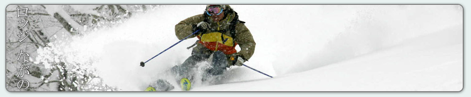
Nozawa Onsen is a very traditional town with beautiful hot springs, friendly locals, and awesome snow. Our Lodge gives you amazing value and we have a range of accommodation to suit any budget.
The Lodge is only 100m to the slopes and short stroll to town
Relaxed and comfortable atmosphere
In the centre of Japan’s main Island Honshu easy access from anywhere
You can fly direct to Tokyo and there is a shuttle bus direct to the Lodge
English and Japanese Speaking Staff to help with all your needs
Unique and beautiful place with breathtaking nature and culture
Nozawa Village is also famous for its hot springs, there are many nearby
Lots of terrain, with Gondolas, high speed quads, and long runs – very few lift lines
Thanks Mark – we were first invited to Nozawa years ago and have been enjoyed the skiing, the village and your hospitality ever since. Thanks for helping us enjoy it so much,
The leftovers. Kelsey finds untracked powder two days ago. Now we wait..
Base at top: 145 cm
Temp at Top: -3 Degree
Base at Uenotaira station: 105 cm
New snow since close: 10 cm
Weather: Overcast
Around 6pm last night we had a brief passing shower. However this quickly turned to snow even in the village. Quite surprising given the warm temperatures. Since last lifts yesterday we have had a total snowfall of 10cm at Yamabiko and 2cm down at village level. We expect temperatures to cool gradually through the day with the freezing level receding to around 800m above sea level. Heavy snow is predicted for tonight. Today the best turns will be had near the summit with the highest quality snow but will be masked by limited visibility. The mid station area will offer slightly slower snow with less crowds and improved visibility. This mid station area gains the highest recommendations for the today a will be a fun way to escape the long weekend crowds for all levels.
Yesterday was an unusual day in the a strong temperature inversion persisted well into the afternoon. At around lunchtime there were positive temperatures recorded at Yamabiko, while it was still well into the negatives in the valley. As such we had an upside down day with fast snow that was great for carving especially down low and softer more forgiving conditions near the top. Crowds were very high but this is to be expected considering the long weekend.
Snow is in the forecast for the foreseeable future with no expected sunshine for the next week at least. Tomorrow we will experience snow showers that will increase in strength overnight. Consistent falls of snow will continue Wednesday, Thursday and Friday probably totalling 30cm or so for each respective 24 hour period. Following this heavier falls are currently modelled for over the weekend easing by early next week. This is one of the most impressive weekly forecasts I can remember.
The wait could be over very soon in here in Nozawa Onsen. After much flip flopping the predictions have come into line once more for the past 24 hours. And they are suggesting something big. From tomorrow afternoon until about the 16th or 17th we are expecting consistent moderate to heavy snow. This is the most impressive run of snow I can remember as far back as dec/jan 2014/15.
To begin with there will be some rain today and early tomorrow from mid mountain and below, snow up high. From then on the heaviest falls of snow looks to be on Tuesday night and then every day from Thursday until Monday. Temperatures will be cold, coldest over the weekend. The perfect wind direction from the north west is checked, hovering at moderate levels for the duration. We will see how much eventuates but our expectations here in Nozawa Onsen are very high indeed.
Right now in the village its clear and calm. I can hear quite a few cars driving up to the parking area so its going to be a busy day on the slopes, as expected for the long weekend. Again groomers will be the pick for the day, smooth and fast early becoming icy up top and softer/slower down low later in the day. Expect high clouds to move over the resort later, but as we will be impacted by easterly weather I don’t think there will be much fog.
Yesterday was a picturesque day on the mountain. Views off to the Sea of Japan, Northern peaks piercing the clouds and even the Hakuba range was visible way off in the distance. Light winds and warm sunshine made for a pleasant days skiing and with the holiday crowds there was a very mellow atmosphere on the slopes. Last night the village was jam packed for the Niko Niko Matsuri, a gigantic contest of paper, scissors rock.
Pavel debuts his Powabungas in the trees yesterday. Even at 136mm underfoot he scored no shortage of face shots.
Base at top: 150 cm
Temp at Top: -8 Degree
Base at Uenotaira station: 100 cm
New snow since close: 0 cm
Weather: Clear
Today is the first day in a while without overnight snowfalls in Nozawa Onsen. We awoke to clear skies and no wind. A classic Japanese bluebird with ample viewing opportunities from the summit of Mt Kenashi. Groomed runs will be smooth and fast early perhaps becoming firmer in the high traffic areas latter in the day. It will be busy on the hill courtesy of another long weekend holiday. There will be a few stashes left early but if your reading this now its too late, the frothing Japanese powder hounds will have smashed it already.
Tonight in the village we have the Niko Niko Matsuri. For those who don’t know its basically a huge game of paper scissors rock that takes place between and crowd all at the same time. Its very fun so well worth checking out. There will also be some free sake, huge drums and even a few local guys dressed in very old school Japanese skiing gear. Starts 7pm in town.
Yesterday was a top day, dare I say the best day of the season? Thanks to less crowds, at least on par with the 50cm powder day a few weeks back. Deep but not bottomless powder, skiable in the trees only in very particular areas up high (such as Yamabiko). We still need more snow! At least another meter. Lets hope next week delivers.
As it goes with very long range forecasts the predictions for next week have backed off a bit. The weather models are doing strange things with unusual small highs and lows crossing Honshu over the next week. Whether or not these eventuate, its making it very hard to make accurate predictions and as a result the forecasts are flip flopping all over the place. Overall, I think we will get snow next week, just on the lower end of the scale compared to a few days ago. At least fairly consistent snowfalls from the week ahead starting Monday night, perhaps totalling a 50-100cm over the weeklong period.
The season is continuing on its upward trend here in Nozawa Onsen. Since last lifts yesterday we have seen snowfalls continue providing an addition 15cm of fresh cover. Excellent riding is to be expected resort wide today with significantly less crowds than there has been (till tomorrows long weekend) and fresh powder in the vicinity of knee deep. It will be hard to pick a poor area to ski today. We expect occasional light flurries this morning, possible clearing to blue sky later this afternoon.
Yesterday was the second best day of the season. There was good coverage above mid station early, less down low. However with continued snowfalls throughout the day conditions became progressively better and by the end there was good coverage top to bottom. At times the lack of crowds and heavy snowfalls made it possible to find fresh tracks on piste, especially around lunchtime. The wind blasting over the upper resort made for many frozen faces and wind loaded slopes in certain areas. Caution should be high for avalanche activity.
Likewise, we are still more than on track for the week of the season (so far) next week. Yesterday a surprise downgrade of the forecast left many keen weather watchers disappointed however the weather models have come into line with an overall upgrade late yesterday. Worst case scenario next week we will have a run of decent snow for four or five days not unlike what we have had the past two. The best case scenario is something we all come to Japan for; bottomless pow and snowfalls measured in the meters. The overall prognosis will become much more certain within two days. Watch this space.
Bringing in the heavy machinery to clear the roads in Nozawa Onsen
Base at top: 140 cm
Temp at Top: -7 Degree
Base at Uenotaira station: 100 cm
New snow since close: 5-10 cm
Weather: Snow
Snow flurries have continued on and off here tonight in Nozawa Onsen. Its hard to measure the amounts fallen with a strong wind blowing across the mountain, as of 8:40am the resort still hasn’t published their updates but i’d estimate 5-10cm overnight up top. With the strong winds certain lifts including the gondola may be placed on wind hold today and expect extremely cold conditions up on Yamabiko (windchill -20). There will be plenty of windblown fresh powder on offer for those who brave the cold. UPDATE: The snow is coming down with increasing amounts here in the village. Going to be a good day up there.
Yesterday was an average day on the mountain until just after lunch when it vastly improved. The morning we saw some moderate wet snowfalls up high and rain down in the village. An extremely thick fog soaked the upper mountain making for hazardous conditions considering the chopped up and occasionally icy snowpack. Around lunchtime the temperatures took a definite chill and it started snowing heavily across the mountain top to bottom. Taking many by surprise the heavy falls provide fresh tracks in certain areas during the afternoon much to the delight of those who persisted from the morning.
The forecast ahead continues to look very good. Going off the current runs a meter over next week would be a conservative estimate. In fact, for the period 10-17th I wouldn’t be surprised of snowfall totals in the region of two meters. A sustained frigid winter setup of consistent snowfalls are predicted over this time period. As these dates draw closer excitement is steadily increasing in accordance with confidence of these figures. In the meantime, after the current snowfall activity we expect a clearing trend to result in mostly sunny conditions over this weekend.