Nozawa Onsen Accommodation, Nagano, The Alps Japan
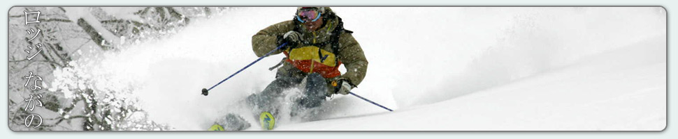
Nestled in the Japan Alps is a magical place steeped in culture and with some terrific skiing and boarding. Nagano was home to the Winter Olympics in 1998.
Get in touch if keen to get knee deep in powder or neck deep in a Hot Spring soon…
Video
Check out our video of our 4 main properties below.
Nozawa Onsen is a very traditional town with beautiful hot springs, friendly locals, and awesome snow. Our Lodge gives you amazing value and we have a range of accommodation to suit any budget.
The Lodge is only 100m to the slopes and short stroll to town
Relaxed and comfortable atmosphere
In the centre of Japan’s main Island Honshu easy access from anywhere
You can fly direct to Tokyo and there is a shuttle bus direct to the Lodge
English and Japanese Speaking Staff to help with all your needs
Unique and beautiful place with breathtaking nature and culture
Nozawa Village is also famous for its hot springs, there are many nearby
Lots of terrain, with Gondolas, high speed quads, and long runs – very few lift lines
Thanks Mark – we were first invited to Nozawa years ago and have been enjoyed the skiing, the village and your hospitality ever since. Thanks for helping us enjoy it so much,
Base at top: 215 cm
Temp at Top: -6 Degrees
Base at Uenotaira: 165 cm
New Snow since close: 15 cm
Weather: clouds clearing to become sunny, mild temperatures and calm winds.
Yesterday was an epic day for the season in Nozawa. Our base smashed through the 200cm mark thanks to 50cm of snow blanketing the mountain in 24 hours. The village is looking very pretty covered in snow, and the mountain even more so. Powder was spread wide and far and it didn’t take long after the runs were groomed for them to become soft and powdery again. Snowflakes continued falling late into the night so there’ll be fresh tracks to be made once again.
Today’s looking cloudy at the moment, but the sun should be shining down upon Nozawa fairly soon. Temperatures are mild and the winds have completely calmed down. We’re getting little glimpses of blue sky and we can’t wait for an awesome day ahead. After the warmer weekend that is coming up, snow is expected for a couple of days so hopefully our base continues to increase.
The skies turned in our favour yesterday afternoon and we were hit with heavy snowfall. Just what we’ve been waiting for! The winds have been strong, blowing snow in all directions, though on the ground we’ve got a good 40cm of fresh so today is definitely a powder day! Clouds and fog are still prevalent so visibility is going to be fairly poor today. We wouldn’t advise venturing into unknown territory. Prevailing North Westerly winds will be easing off late in the evening, taking the clouds with them to leave us with a clear, cold night and a beautiful bluebird day tomorrow.
We’re happy to see that the expected rain that was forecast for the weekend has been downgraded. Hopefully it continues in this direction. Unfortunately, temperatures are still expected to rise into the mid single digits, though this won’t be for long with colder temperatures and lots of snow to come at the start of the new week.
After a beautiful and mild bluebird day on the slopes yesterday, the skies are looking much cloudier today. The forecast is telling us that we may see between 25-30cm of snow today, though there are still some blue patches in the sky and no sign of snowflakes yet. Our fingers are crossed! Winds will be picking up fairly fast today to reach speeds of 55 km/h. We won’t feel it so much in the village, but up the top it’s going to be cold and windy today. The strong winds may continue into Wednesday as well, hopefully not blowing away any fresh snow that’s landed. Thursday is looking much like yesterday, blue skies all around. Who’s looking forward to another bluebird day?
Although it’s still four days away, The weekend isn’t looking too exciting, with temperatures rising above zero and some rain predicted to fall. Hopefully the snowpack will hold strong through the warmer temps as there is a nice lot of snow predicted to come after the weekend once the temperatures drop.
Weather: Blue skies for the moment, possible snow flurries
The sun is shining brightly over Nozawa this morning. After 15 odd centimetres of snow yesterday, the pistes should be groomed to perfection. We’re glad to have seen some snow falling yesterday to make up for what we didn’t get on Saturday. Looking at the webcams now, it looks like it’ll be a beautiful day up on the slopes; clear skies in every direction, though the forecast is predicting snow showers during the day… A nice dusting of snow could be heading our way.
Westerly to North-Westerly winds will be increasing overnight before reaching near gales on Tuesday afternoon through till Wednesday. There’s a decent lot of snow forecast to fall throughout that time so hopefully the wind doesn’t blow it off the mountain.
Looking further into the forecast, it’s looking like there’ll be a few warmer days over the weekend with some possible rain hitting us. We’re going to sit tight and hope that things change in our favour.
On a more positive note, challenge 39° has opened so that should be a bit of fun; the steepest run in Nozawa!
The great piste conditions and the nice weather up on the hill made up for an unfortunate turn of events in the skies yesterday. Our predicted dump of 30cm never materialised and we were left with not a whole lot in the way of snow. As for now, well it’s been snowing moderately for a few hours and we’ve got a fresh coating of 10cm on the mountain. Snow is expected to fall through till the afternoon, though we can’t say that for certain as this storm seems to be a hard one to predict. We’re just going to enjoy what we can get. Temperatures today will be cold, at around -12 up the top, it would be wise to rug up.
With the freezing level down at 0m, we’re seeing snow blanket the whole mountain. This reading should stay below the village level for the next few days so our next lot of snowfalls will reach us down here as well. There’s another storm on its way that should be taking form on Tuesday morning with moderate snowfalls predicted. Winds will be getting stronger into the week so the windchill will be something to keep in mind when dressing yourself and your children for the slopes.