Nozawa Onsen Accommodation, Nagano, The Alps Japan
Nestled in the Japan Alps is a magical place steeped in culture and with some terrific skiing and boarding. Nagano was home to the Winter Olympics in 1998.
Get in touch if keen to get knee deep in powder or neck deep in a Hot Spring soon…
Video
Check out our video of our 4 main properties below.
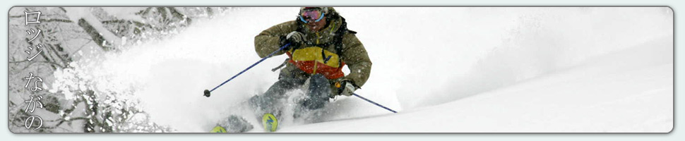
Nozawa Onsen is a very traditional town with beautiful hot springs, friendly locals, and awesome snow. Our Lodge gives you amazing value and we have a range of accommodation to suit any budget.
The Lodge is only 100m to the slopes and short stroll to town
Relaxed and comfortable atmosphere
In the centre of Japan’s main Island Honshu easy access from anywhere
You can fly direct to Tokyo and there is a shuttle bus direct to the Lodge
English and Japanese Speaking Staff to help with all your needs
Unique and beautiful place with breathtaking nature and culture
Nozawa Village is also famous for its hot springs, there are many nearby
Lots of terrain, with Gondolas, high speed quads, and long runs – very few lift lines
Thanks Mark – we were first invited to Nozawa years ago and have been enjoyed the skiing, the village and your hospitality ever since. Thanks for helping us enjoy it so much,
With the summit of Mt Kenashi sitting at -6C we are back to near normal temperatures for this time of year in the Nozawa Onsen area. However a lack of fresh snow means conditions will be similar to your typical dry spell in other ski areas. Resort slopes are hard and icy on the upper mountain today and the lower slopes will be slushy but fast. Some sun will improve things however only brief patches of clear sky are forecast for today. Off piste areas should be avoided at all costs as they remain as chopped ice. More snow or sun is required here.
Yesterday we saw the best skiing on the lower mountain which was nice and slushy but fast. Crowds were low and quick laps of the challenge area accessed via the Hikage gondola was the best bet. The upper mountain was soaked in a thick disorientating fog that made skiing very difficult indeed.
Another warm spell is forecast for tomorrow and with this the skiing should improve across the upper mountain with the softening effects of warmth. Rain is also forecast however hopefully this holds off until late afternoon. Tomorrow night some moderate falls of snow to low levels is predicted, continuing into the weekend. In the long range we have rain events predicted for Sunday Monday and mid next week. Both are followed by moderate snow to low levels. The weather is extremely variable at the moment. Hopefully it soon settles into the typical spring pattern of sun with a weekly dump of fresh powder.
Things have cooled off in Nozawa Onsen slightly today. Instead of Mt Kenashi summit temperature sitting well into the positives like yesterday it has dropped to -3C. Furthermore, the precipitation we experienced yesterday looks to have cleared for now as has the dense fog that hovered over the mountain yesterday. We can expect icy conditions today on the upper mountain, slushier down low. But at least the snow will be fast.
Yesterday was pretty bad. Light rain stuck around for most of the day and all but the most well ridden pistes were sticky and wet.
We continue to have a extremely variable forecast with huge ups and downs in the freezing level. Its very hard to trust the accuracy of the forecast beyond three days at the moment. Today we should see isolated snow showers above around 800 meters, continuing to around 700 meters into tomorrow. On Thursday another warm front is forecast with the possibility of rain. Snow is a possibility on Friday.
With light rain showers meandering over Nozawa Onsen today marks a good down day to rest and recuperate. Overnight rainfall in combination with warm temperatures has turned the snow into moist slush that is sticky in all but the most well trafficked areas. Head up to Yamabiko for slightly better snow quality.
Luckily the freezing level is forecast to decline later in the day and the rain will turn to snow above 1000 meters. The freezing level will remain at this elevation with isolated showers until Thursday when another spike in temperatures is predicted. Following this some moderate to significant snow across the mountain is forecast for Friday.
Groms smashing some powder turns at Yamabiko yesterday.
Base up top: 460 cm Temp Top; 1 Degrees
Base at bottom; 280 cm
New Snow since close: 0 cm
Weather; Clear
So far its a clear one in Nozawa Onsen with visibility as good as it gets. We have some high cirrus cloud beginning to move over the resort and while it looks spectacular, this tends to indicate approaching fronts. In combination we have some moderate breezes on the upper slopes, true mountain weather. Today the groomed runs will be the pick and these will be fast in the morning, becoming slower during the afternoon, particularly so if the forecasted precipitation eventuates.
Yesterday we saw some of the best long range visibility all day. This is unusual as long range views are usually interrupted by a photochemical haze during the afternoon. The Sea of Japan was visible off to the west, all the surrounding 3000 meter peaks including the Hakuba Range and even Sado Island, well offshore, was easily visible. Probably the clearest day of the season so far. Likewise, the skiing and boarding was better than expected. Snow quality at Yamabiko remained dry all day where as the lower slopes became slushy in the warm sun, but did not have any lack of pace.
We have a real mixed bag according to the forecast. Rain is expected later today and tonight, tending to snow on the peaks by tomorrow. We may then have a clear morning on Tuesday followed by some isolated snow showers and much colder temperatures by the afternoon continuing into Wednesday. The next significant snowfall looks to occur around Friday next week. Continuing on the trend of good Saturdays this season, Saturday looks like it will be the best day this week.
What a morning it is here in Nozawa Onsen. Light winds, a clear upper atmosphere and cold temperatures. We have some low cloud in the valleys that makes for a nice cloud sea backdrop from the summit but these are expected to dissipate. -7C at the summit, the temperatures are colder than expected and this will ensure excellent snow quality, at least before it warms later in the day. No fresh snow to report overnight.
Yesterday the ample fresh snow saw very fun skiing and the groomed runs were superb in the morning before becoming choppy later in the day. The snow yesterday fell at higher temperatures than usual so while quality was very good in the morning, lower slopes became heavy during the afternoon, an effect of the heat of the day.
Today marks the beginning of a bit of a warm spell. Temperatures are forecast to rise quickly peaking at around 2400m tomorrow. Rain is looking likely for tomorrow afternoon and into Monday but this should return to snow early next week once the freezing level declines again.