Nozawa Onsen Accommodation, Nagano, The Alps Japan
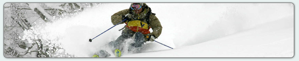
Nestled in the Japan Alps is a magical place steeped in culture and with some terrific skiing and boarding. Nagano was home to the Winter Olympics in 1998.
Get in touch if keen to get knee deep in powder or neck deep in a Hot Spring soon…
Video
Check out our video of our 4 main properties below.
Nozawa Onsen is a very traditional town with beautiful hot springs, friendly locals, and awesome snow. Our Lodge gives you amazing value and we have a range of accommodation to suit any budget.
The Lodge is only 100m to the slopes and short stroll to town
Relaxed and comfortable atmosphere
In the centre of Japan’s main Island Honshu easy access from anywhere
You can fly direct to Tokyo and there is a shuttle bus direct to the Lodge
English and Japanese Speaking Staff to help with all your needs
Unique and beautiful place with breathtaking nature and culture
Nozawa Village is also famous for its hot springs, there are many nearby
Lots of terrain, with Gondolas, high speed quads, and long runs – very few lift lines
Thanks Mark – we were first invited to Nozawa years ago and have been enjoyed the skiing, the village and your hospitality ever since. Thanks for helping us enjoy it so much,
Its a picturesque clear blue morning in Nozawa Onsen with a beautiful pink alpinglow on surrounding peaks. Today will be a day definitely worthy of bringing the camera up the hill. Although the snow became heavier yesterday with the sunshine and increased temperatures, very cold overnight will have sucked a proportion of the moisture out of the snow improving the quality. Groomed pistes will have that silky finish whilst the trees still have the occasional patch of untracked fresh.
The forecast is stacked with positivity at the moment. First up, more snow is expected to fall tonight, around 10-15cm before another clear day is predicted for Saturday. Following this another extended run of very cold temperatures and snowfall will occur commencing Sunday. At this stage the heaviest falls will occur on Sunday and Monday night while totals could be very similar to the most recent dump which delivered 1.5m of fresh to Nozawa Onsen.
Seems like the first morning in about a week where we haven’t had more than 30cm of overnight falls. Not to scoff at the 5-10cm we received overnight tonight. Like every day this week the conditions will be impeccable with a fresh coating of light dry pow mostly covering tracks from previous days. Trees will be great, groomed runs will be great, everywhere will be great! Its forecast to clear this morning so we could be in for a bluebird stunner.
What more could be said than how yesterday continued on the trend of epic days. The snow was deep, the lift lines were short and it continued to snow lightly for most of the day. Most tree areas were bombed very quickly as there seems to be an inordinate number of powder enthusiasts about the village at the moment. Easy to understand considering Nozawa Onsen is having one of the best seasons worldwide this year.
Looking at the forecast ahead the run of exceptional snow conditions is earmarked to continue. A break in heavy snowfalls is suggested for the rest of this week but with cold temperatures enduring and a light top up on Friday the snowpack won’t degrade. Another strong system is predicted commencing on Sunday and persisting well into next week with heavy snowfalls throughout. It looks like we may be having another meter and a half dump!
We still have some light snow falling in the village of Nozawa Onsen. Conditions are as good as it gets with deep fresh powder absolutely everywhere. It will be hard to find a bad spot to ski in bounds today. The groomed runs will be soft and forgiving and the trees will be loaded with neck deep japow, all the good stuff! But be careful when venturing out today. Two groups went missing yesterday taking a wrong turn and becoming trapped in the deep powder, they have since been found. Best to avoid out of bounds areas today even with equipment and of course never ever ride alone.
Yesterday was amazing. It was hard to top the snow conditions from Sunday, however the lower crowds and full speed gondola made sure of the day being even better. Everyone was frothing so much so that many areas were smashed far quicker than normal.
According to the forecast for today snowfalls should continue, gradually becoming isolated with breaks of clear sky. Tomorrow is predicted to be partly cloudy whilst Thursday will be clear. Further snowfalls are predicted for Friday with variable clear/snow conditions following.
Ridiculous. That was what yesterday was like. The depth of the snow was real up there, probably the third deepest day of the season. Wind loaded slopes were around chest to neck, all other slopes around waist. If you weren’t on your game you paid the price with many frustrating entrapments but if you kept the rhythm going the reward was some of the best powder turns on the planet.
Snow continued to fall all day yesterday becoming lighter overnight. Since last lifts yesterday an additional 30-40cm has fallen bringing the storm total to 120cm in 48 hours. Skiing and boarding today will again be epic with the overnight falls refreshing tracked areas. The snow has also had time to settle making the deep snow even more manageable and hopefully improving the stability, which was extremely low yesterday.
The forecast indicates snow will continue at light to moderate levels for the rest of the day becoming isolated and less frequent tomorrow. Isolated falls will then continue in combination with light winds and occasional breaks of sunshine from Wednesday to Friday. Saturday is forecast to be clear at this stage but confidence on these long range predictions is low.
Its on!! 45cm of ultra dry blower pow has descended overnight. Conditions will be exceptional and that icy base layer with cookies will be mostly buried out of sight but not out of mind. Avalanche danger will be very high. Get out there and enjoy, but be safe.
Yesterday saw a blizzard rage for most of the day. Strong winds meant the gondola was running very slow and blowing snow with cloud severely reduced line of sight and definition in open areas. But the lower trees and pistes were very fun indeed with knee to waist deep blown snow.
Moderate snowfalls should continue for the remainder of today, becoming light tomorrow and receding to isolated falls by Tuesday. Some sunshine is a possibility for Wednesday but snow is set to return in the second half of the week with around three distinct dumps on the horizon.