Nozawa Onsen Accommodation, Nagano, The Alps Japan
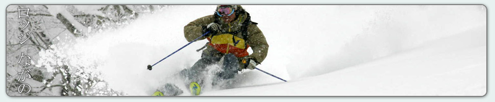
Nestled in the Japan Alps is a magical place steeped in culture and with some terrific skiing and boarding. Nagano was home to the Winter Olympics in 1998.
Get in touch if keen to get knee deep in powder or neck deep in a Hot Spring soon…
Video
Check out our video of our 4 main properties below.
Nozawa Onsen is a very traditional town with beautiful hot springs, friendly locals, and awesome snow. Our Lodge gives you amazing value and we have a range of accommodation to suit any budget.
The Lodge is only 100m to the slopes and short stroll to town
Relaxed and comfortable atmosphere
In the centre of Japan’s main Island Honshu easy access from anywhere
You can fly direct to Tokyo and there is a shuttle bus direct to the Lodge
English and Japanese Speaking Staff to help with all your needs
Unique and beautiful place with breathtaking nature and culture
Nozawa Village is also famous for its hot springs, there are many nearby
Lots of terrain, with Gondolas, high speed quads, and long runs – very few lift lines
Thanks Mark – we were first invited to Nozawa years ago and have been enjoyed the skiing, the village and your hospitality ever since. Thanks for helping us enjoy it so much,
Kicking things off in Nozawa Onsen today with mild overcast conditions. Its still in the negatives at the summit so the skiing will be fair to good across the mountain, good on piste and fair off piste. Expect spring-like snow. There are a few celebrations in various lodges for Australia day. Lodge Nagano and Villa Nozawa have some great ice bars with the lodge crew even building a sweet mini terrain park. Anyone is welcome to come listen to some tunes in the triple j hottest 100 and join in on the fun.
Yesterday was very similar to today in regards to conditions with warm mostly cloudy weather. Still the skiing was quite nice on the groomed runs and shaded north facing gullies. Rain is expected later today and tomorrow. Lets hope it holds off as long as possible.
A very positive forecast is lining up for the next ten days. After todays bout of warm weather we then expect and extended period of cold and very snowy weather. The most sizeable dumps are predicted for Tuesday night and then again on Friday night into Saturday. So all in all a very good week ahead.
One of the best days of the season yesterday? The words were certainly tossed around quite a bit yesterday afternoon by frothing skiers and boarders descending from the hill. Id give it a top five finish personally. The weather, the views, the snow, the only downside was the weekend crowds that luckily spread out after the morning rush. Yes, the exposed slopes became sun affected during the afternoon but the shaded gullies held snow that was perfect for charging. The light air moving glittering ice particles about the upper trees added a remarkable, even magical feel to the mountain. Top stuff.
This morning we have had some misty cloud traverse over the local area. The forecast suggests a partly cloudy day so it remains to be seen whether the fog will stick around or clear later. With a southerly winds warming temperatures the snow will be slightly heavier today, but again, the shaded gullies will retain all the good stuff. Crowds may be a bit hectic earlier, top picks for the day, the mid station area for beginners with cruisy uncrowded slopes and Challenge area for advanced riders.
When we analyse the forecast its quite obvious that tomorrow will be touch and go. Rain is a distinct possibility but luckily a cold front is due on Tuesday around lunch returning snow and very cold temperatures to the region and enduring to Friday at least.
Base up top: 410 cm Temp Top; -8 Degrees
Base at bottom; 250 cm
New Snow since close: 20 cm
Weather; Mostly cloudy
Today is going to be epic. A clearing trend is well in effect, deep, deep powder and light winds. All the hallmarks are ticked. Hit up the tree skiing areas first up. Yamabiko and Challenge will both be good, once these areas are tracked the hot tip is to explore and enjoy!
Yesterday was so much better than expected. With all the rain that we had the previous 24 hours no one was really expecting much other than dust on crust conditions. Luckily we were all proved wrong. There was deep, dry windblown powder across most of the resort, especially in the gullies which became deeper during the day as heavy snowfalls persisted. A nice surprise.
Make the most of conditions today as we head into a bit of a warm spell over the next three days or so. Tuesday will mark an end to the adverse weather and snow with cold temperatures will return. In fact the second half of the week onwards is shaping up to be a run of very good snowfalls and cold temperatures.
While its raining down in the village it is snowing hard on the upper mountain with 20cm recorded since last lifts. So there will be some nice riding on the upper slopes, especially above 1200m where rain has not affected the snowpack. Time to get out there and enjoy!
According to the forecast temperatures will warm over the next few days with the freezing level rising to around 1500 meters. A strong front is then forecast for mid next week with heavy snowfalls expected.
If you want to ski today then make sure you get up on the hill as early as possible as rain is in the forecast for all but the very upper slopes. Otherwise it could be a good day to take a rest, avoiding the inclement weather. Perhaps explore Nozawa’s winding streets and alleys, visiting the nearby snow monkeys or taking the onsen challenge. Can you do all thirteen free onsens in one day? For those still keen on hitting the hill it will be quite nice on the groomed runs with some quality wax on your base and a waterproof outer layer.
Yesterday started with the promise of sun but by mid morning the clouds moved back in obscuring beautiful long range views. No worries when there is powder around. Fresh tracks from top to bottom were found all day long and even though the snow became heavier it was still great fun for all involved. Those attacking the groomers were rewarded with nice smooth slopes that held good speed underfoot.
According to the forecast the freezing level should gradually decline today from 1500 meters this morning to 600 meters overnight, reaching zero by tomorrow afternoon. Moderate precipitation amounts are expected from now till tomorrow afternoon, heaviest overnight. A clearing trend is expected Friday night with Saturday a perfect bluebird. Variable conditions early next week and then a solid dump later next week.