Nozawa Onsen Accommodation, Nagano, The Alps Japan
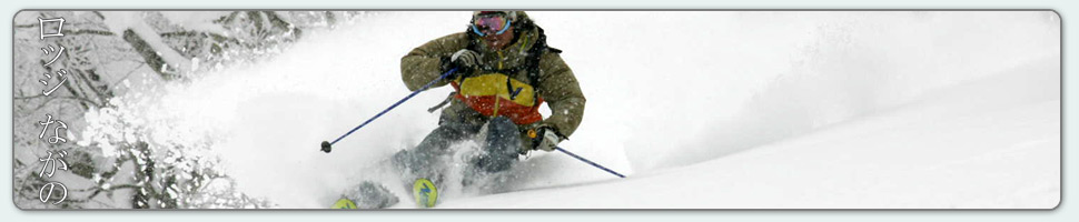
Nestled in the Japan Alps is a magical place steeped in culture and with some terrific skiing and boarding. Nagano was home to the Winter Olympics in 1998.
Get in touch if keen to get knee deep in powder or neck deep in a Hot Spring soon…
Video
Check out our video of our 4 main properties below.
Nozawa Onsen is a very traditional town with beautiful hot springs, friendly locals, and awesome snow. Our Lodge gives you amazing value and we have a range of accommodation to suit any budget.
The Lodge is only 100m to the slopes and short stroll to town
Relaxed and comfortable atmosphere
In the centre of Japan’s main Island Honshu easy access from anywhere
You can fly direct to Tokyo and there is a shuttle bus direct to the Lodge
English and Japanese Speaking Staff to help with all your needs
Unique and beautiful place with breathtaking nature and culture
Nozawa Village is also famous for its hot springs, there are many nearby
Lots of terrain, with Gondolas, high speed quads, and long runs – very few lift lines
Thanks Mark – we were first invited to Nozawa years ago and have been enjoyed the skiing, the village and your hospitality ever since. Thanks for helping us enjoy it so much,
Its a beautiful day out there this morning with clear blue skies a backdrop for the elevated Japanese Alps. Make sure you bring your camera up today to capture the views before the clouds roll over this afternoon. There will be some nice skiing across the resort. With gradually warming temperatures its recommended to make any powder skiing efforts earlier on otherwise heavy snow will result. The groomed runs will really be the better of the two today.
Outstanding conditions persisted most of the day yesterday with fairly deep powder snow across the resort. Visibility was limited on the upper areas of the resort but the lower trees were sensational loaded with waist deep japow. Nice!
Looks like we have some snow on the way for tomorrow. It will fall about the peaks by lunchtime before lowering overnight. Around 20-30cm is predicted at this stage. Light falls will likely continue into Friday before clearing for the weekend. Further ahead, the next dump is predicted for mid next week.
What crazy day it was yesterday! In the morning we had one patch of blue sky but come about 10am the clouds rolled in from the sea of Japan and dumped snow hard over the resort. With such an intense rate of accumulation during the afternoon it wasn’t long before tracks were covered, especially with increasing winds blowing snow. Last lifts at Yamabiko saw almost untracked conditions.
Today is a different story with light flurries across the area. Winds will become lighter during the day and as they shift to the south west we should expect the skies to gradually clear. Good skiing and boarding will be had today, expect the snow to be similar to Sunday with wind compacted powder, deeper in the higher areas but less wind affected in the lower areas. Oh, and as of this morning the 4m mark has been cracked for upper base depth. Good times.
With southerly winds expected tomorrow there should be mostly fine weather. Light snow should increase to moderate rates of accumulation on Thursday. We initially expected a strong system overnight Thursday but this has backed off to more moderate levels. On the weekend there may be partly cloudy weather.
We expect some snowfalls in Nozawa Onsen today but as of 7am they were not as yet on the radar. This is often the case with predicted weather events; they are usually delayed by about 4-6 hours behind forecasted timings. Nevertheless, snow should fall down to about 500m today, possibly around 10-15cm will accumulate. There will be strong winds about the peaks so keep this in mind when dressing for the day, and extra layer certainly wouldn’t hurt. The snow base is pushing up towards the 4m mark, expect it to be cracked by the weeks end.
Yesterday continued on this seasons tradition of great days. The snow was dry but very wind compacted for this area making for a perfect landing off one of the thousands of wind features across the hill. Stability had also improved slightly. Traffic on the groomers was low and as a result they remained smooth and mostly free of moguls all day.
Snowfalls should ease tomorrow, becoming isolated throughout the day before clearing completely by Wednesday. Prefrontal warm temperatures are forecast in combination with sun and light wind at this stage. Further ahead, the next significant snowfalls are due Thursday into Friday. Expect quite a bit of snow out of this front, the exact amounts will become clearer closer to the date.
Today is going to be a good day. After some extremely strong winds and snow last night the intense conditions have eased during the early hours producing a mostly overcast morning with the occasional blue sky patch. Accumulated totals since last lifts have amounted to approximately 10-20cm of windblown snow. We may see possible additions to this throughout the day with the occasional flurry predicted. Avalanche conditions remain extremely hazardous.
Yesterday saw a blizzard rage for a large proportion of the day. The skiing and boarding was excellent provided the right spot was selected. One well hidden from the breeze such as the dense tree areas and lower groomed runs as such.
A slightly improved forecast is predicted for the coming days. More snow is suggested for tomorrow, around 10-15cm throughout the day and night receding to variable weather with a few light flurries on Tuesday and Wednesday. Fairly strong snowfalls are predicted for Thursday, heaviest overnight.
As expected we awoke this morning to heavy flurries in Nozawa Onsen. With 5-10cm of fresh recorded up top it is clear that the snow probably started around 4-5am. Wind is a factor at the summit with varying amounts collecting at similar elevations, make sure you rug up with an extra layer. Today the best runs will be on the tree lined groomers and low angled trees. With extremely hazardous avalanche conditions yesterday, moderate angle slopes were sliding at the drop of a hat, its best to avoid the steeper slopes today. Safety first.
Yesterday was quite a nice day. Warmer than very cold temperatures lingered being around -4C at the summit and so as a result the snow was heavier than normal powder from around here. We could say the snow was like ‘Australian pow’. Nevertheless it was good skiing and boarding for those who pushed through a solid hangover, or the sensible ones who didn’t have too much sake the night before. Mostly fine weather meant it was a good day to explore the lesser known areas of the resort.
There is an improved forecast for the next four days or so with moderate falls expected most days. The freezing level is a bit up and down but not expected to rise above 300m. Varying quality of the snow will not be discernible to the average rider but there will be slight changes from day to day.